Precision Intelligence. Global Impact.
SwanSAT delivers asset level intelligence to enterprises across agriculture, disaster response, banking, surveillance and infrastructure.
About swansat
SwanSAT is a geospatial intelligence company that turns satellite data into audit-ready outputs built for the precision, scale and accountability that institutional decisions demand. Where others provide data, we provide intelligence you can act on and defend.
SOLUTIONS
Integrated Intelligence Across Sectors
Agriculture
Disaster
Surveillance
Infrastructure
BFSI
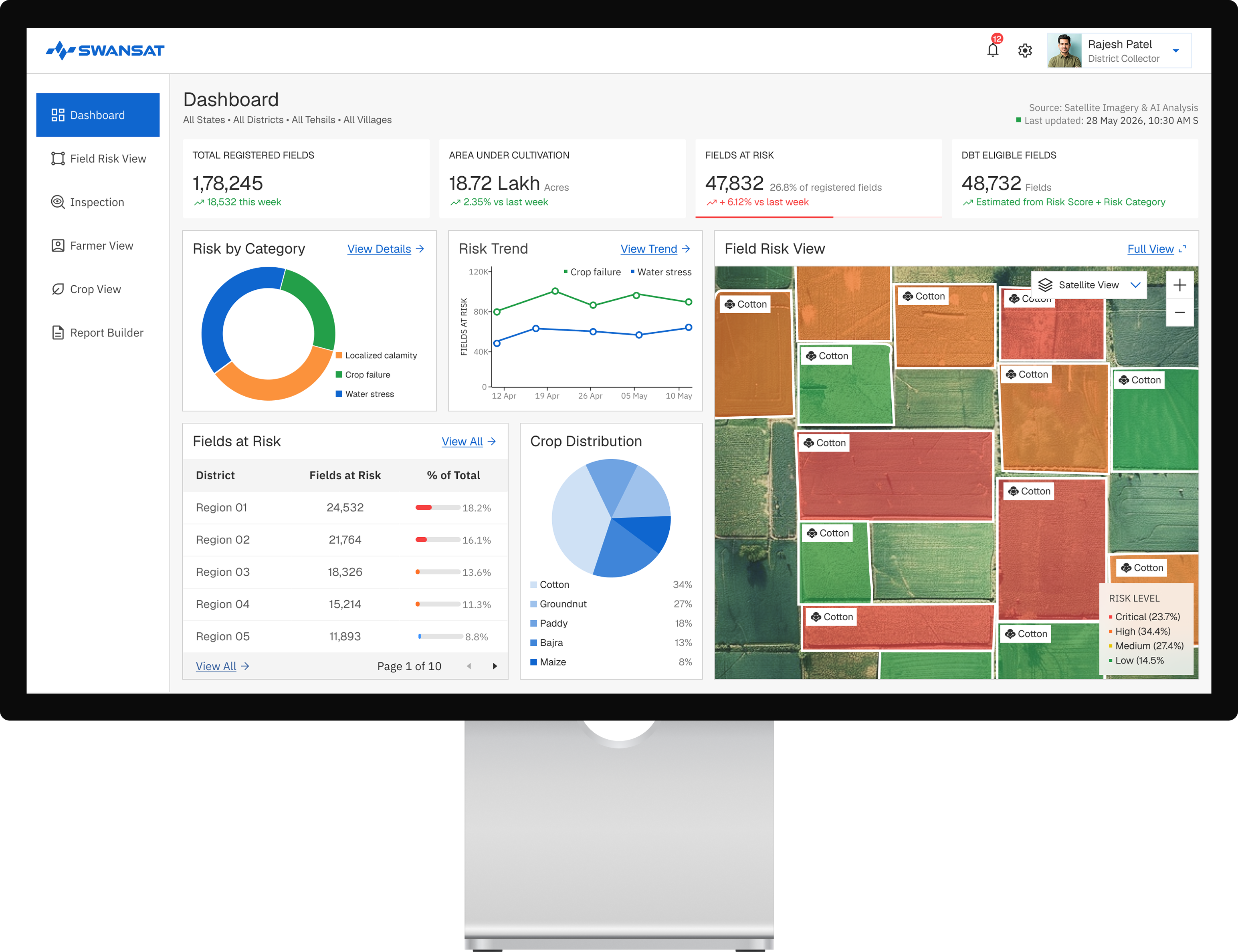
Field Level. Crop Specific. Continuously Monitored.
End to end crop intelligence, from sowing through harvest, built for institutional scale and individual field precision.
SwanSAT delivers continuous crop intelligence to agribusinesses and institutions across the full agricultural cycle. Every output is specific to an individual field, verifiable and built for scheme administration, procurement planning and farm advisory at scale.

Crop classification across 100+ crop types
Field level sowing and harvest date detection
Crop stress monitoring and early detection
Irrigation demand and water stress monitoring
Yield forecasting and production estimation
Crop damage assessment

KhetPe
Direct-to-farmer intelligence, in every pocket.
Learn More about KhetPe →


TECHNOLOGY
Built for Complexity.
Trusted for Execution.
Industry Standard
SwanSAT Capability
Unimodal
Single optical sensor, one data source
Multimodal
SAR, optical and thermal fused into one platform
Low resolution
Pixelated imagery updated every two weeks
High resolution
Precise imagery available every day
Cloud cover blindness
Optical sensors fail in monsoon and overcast conditions
Hyperlocal Weather Intelligence
Imaging continues through rain, cloud and low light
Regional Weather
District level forecasts averaged across large areas
Hyperlocal Weather
Field specific conditions updated four times daily
Our Process
How We Work
01


Data Ingestion
SwanSAT continuously captures satellite data across SAR, optical, thermal and weather sensors. Unlike single-source systems, our ingestion pipeline operates through cloud cover, monsoon conditions and low-light environments without interruption.
02


Harmonization
Data from every sensor is calibrated, time-aligned and fused into a single geospatial layer. The result is a consistent, deployment-grade view of any terrain, regardless of which sensor captured it or when.
03


AI Models
SwanSAT's AI models are trained on Indian conditions, crop types, terrain and climate patterns. They extract field level accuracy for agriculture and asset level precision for infrastructure, surveillance and disaster response.
04


Intelligence Layer
Every output is traceable to its source data and built to withstand institutional scrutiny. Whether it is a yield estimate, a flood extent map or a stability report, the intelligence is audit-ready before it leaves the platform.
05


Dashboards and APIs
Intelligence is delivered through configurable dashboards built for government and enterprise workflows, and through secure APIs that integrate directly into existing systems. No new infrastructure required on the client side.
ENTERPRISE READY
Security, Governance and Reliability Built for Institutional Deployments
Designed for governments, financial institutions and critical infrastructure operators that require secure access, auditable workflows and dependable intelligence at scale.
Role-Based Access Control
Granular permissions ensure that teams, departments and stakeholders access only the information relevant to their responsibilities.

Secure Cloud Infrastructure
Enterprise-grade cloud architecture designed for secure processing, storage and delivery of large-scale geospatial intelligence.

Enterprise API Integrations
Seamlessly integrate intelligence outputs into existing government systems, enterprise applications and operational workflows

Audit-Ready Intelligence
Every insight, alert and analytical output is traceable back to its source data, enabling transparency, compliance and confidence in decision-making.

PRODUCTS
Deployment-Ready Applications
SwanSAT builds custom geospatial intelligence solutions across every sector it operates in. For teams that need to move fast, we offer deployment-ready products built on the same multi-sensor intelligence platform and available on demand. For everything else, we build to requirement.
KhetPe
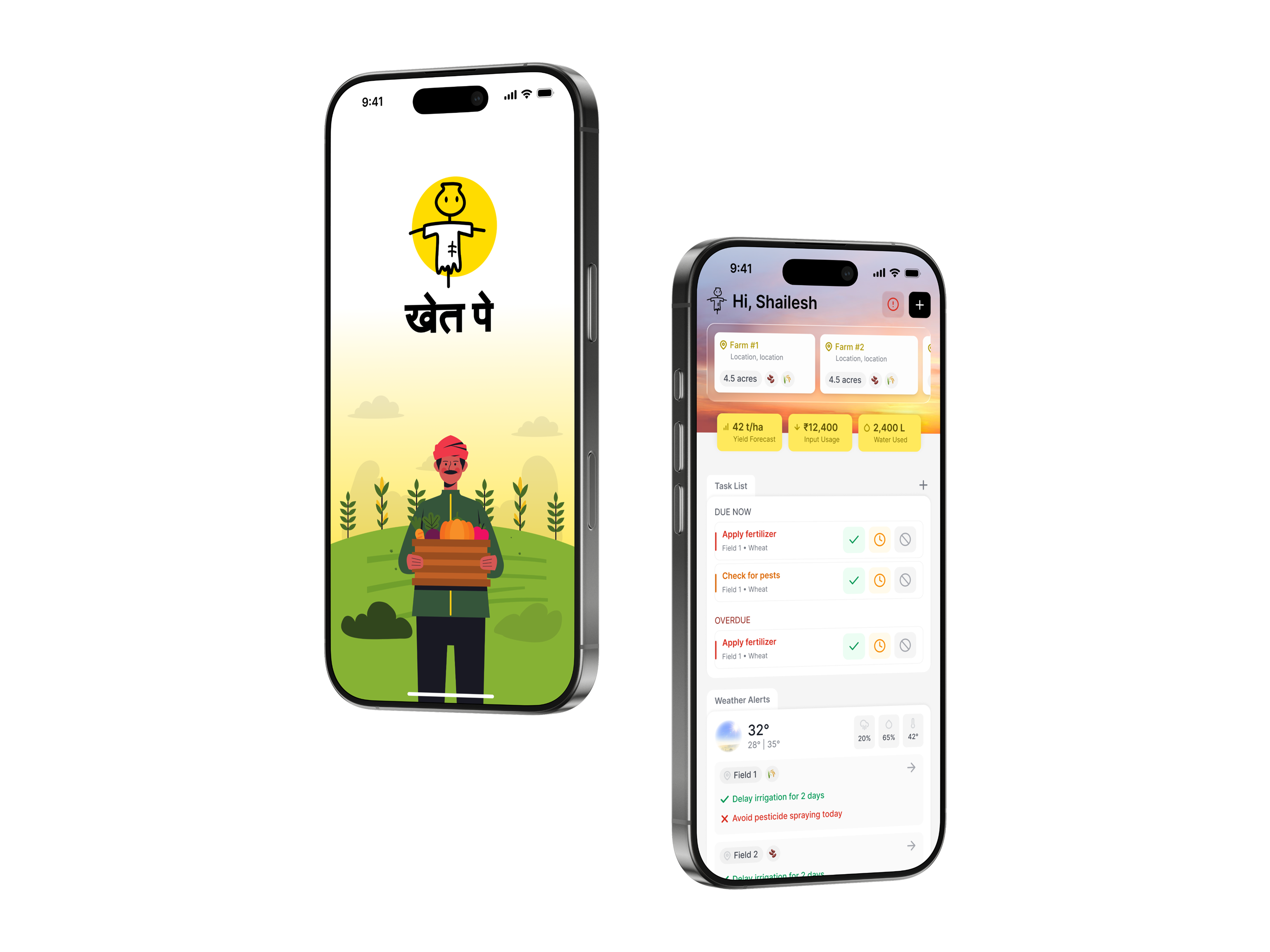
Direct-to-farmer intelligence, in every pocket
Our mobile app gives smallholder farmers access to hyperlocal weather insights, soil health analysis, crop growth forecasting, and irrigation planning — powered by daily satellite analytics.

Hyperlocal Weather & Moisture Analysis
Crop Growth & Soil Health Tracking
Precision Irrigation Planner
Integrated Insurance Claims
Integrated Insurance Claims
Learn More about KhetPe →


Contact us
Speak With
Our Intelligence Team.


Precision Intelligence. Global Impact.
SwanSAT delivers asset level intelligence to enterprises across agriculture, disaster response, banking, surveillance and infrastructure.
About swansat
SwanSAT is a geospatial intelligence company that turns satellite data into audit-ready outputs built for the precision, scale and accountability that institutional decisions demand. Where others provide data, we provide intelligence you can act on and defend.
SOLUTIONS
Integrated Intelligence Across Sectors
Agriculture
Disaster
Surveillance
Infrastructure
BFSI
Field Level. Crop Specific. Continuously Monitored.
End to end crop intelligence, from sowing through harvest, built for institutional scale and individual field precision.
SwanSAT delivers continuous crop intelligence to agribusinesses and institutions across the full agricultural cycle. Every output is specific to an individual field, verifiable and built for scheme administration, procurement planning and farm advisory at scale.
Crop classification across 100+ crop types
Field level sowing and harvest date detection
Crop stress monitoring and early detection
Irrigation demand and water stress monitoring
Yield forecasting and production estimation
Crop damage assessment

KhetPe
Direct-to-farmer intelligence, in every pocket.
Learn More about KhetPe →


TECHNOLOGY
Built for Complexity. Trusted for Execution.
Industry Standard
SwanSAT Capability
Unimodal
Unimodal — optical imagery from open-source Sentinel only
Multimodal
SAR, optical and thermal fusion for accurate, all-weather insights
Low resolution, fortnightly revisit
Fortnightly frequency, pixelated images
High resolution
High resolution, daily revisit — precise imagery available every day
Cloud cover Blindness
Blinded in monsoon and overcast conditions
SAR
Imaging continues through rain, cloud and low light
Regional Weather
District level averages that cannot differentiate between adjacent fields
Hyperlocal Weather
High resolution weather — field specific conditions updated four times daily
Our Process
How We Work
01
Data Ingestion
SwanSAT continuously captures satellite data across SAR, optical, thermal and weather sensors. Unlike single-source systems, our ingestion pipeline operates through cloud cover, monsoon conditions and low-light environments without interruption.
02
Harmonization
Data from every sensor is calibrated, time-aligned and fused into a single geospatial layer. The result is a consistent, deployment-grade view of any terrain, regardless of which sensor captured it or when.
03
AI Models
SwanSAT's AI models are trained on Indian conditions, crop types, terrain and climate patterns. They extract field level accuracy for agriculture and asset level precision for infrastructure, surveillance and disaster response.
04
Intelligence Layer
Every output is traceable to its source data and built to withstand institutional scrutiny. Whether it is a yield estimate, a flood extent map or a stability report, the intelligence is audit-ready before it leaves the platform.
05
Dashboards and APIs
Intelligence is delivered through configurable dashboards built for government and enterprise workflows, and through secure APIs that integrate directly into existing systems. No new infrastructure required on the client side.
ENTERPRISE READY
Security, Governance and Reliability Built for Institutional Deployments
Designed for governments, financial institutions and critical infrastructure operators that require secure access, auditable workflows and dependable intelligence at scale.
Role-Based Access Control
Granular permissions ensure that teams, departments and stakeholders access only the information relevant to their responsibilities.

Secure Cloud Infrastructure
Enterprise-grade cloud architecture designed for secure processing, storage and delivery of large-scale geospatial intelligence.

Enterprise API Integrations
Seamlessly integrate intelligence outputs into existing government systems, enterprise applications and operational workflows

Audit-Ready Intelligence
Every insight, alert and analytical output is traceable back to its source data, enabling transparency, compliance and confidence in decision-making.

PRODUCTS
Deployment-Ready Applications
SwanSAT builds custom geospatial intelligence solutions across every sector it operates in. For teams that need to move fast, we offer deployment-ready products built on the same multi-sensor intelligence platform and available on demand. For everything else, we build to requirement.
KhetPe
Direct-to-farmer intelligence, in every pocket
Our mobile app gives smallholder farmers access to hyperlocal weather insights, soil health analysis, crop growth forecasting, and irrigation planning — powered by daily satellite analytics.
Hyperlocal Weather & Moisture Analysis
Crop Growth & Soil Health Tracking
Precision Irrigation Planner
Integrated Insurance Claims
Integrated Insurance Claims
Learn More about KhetPe →


Contact us
Speak With
Our Intelligence Team.


Contact

Precision Intelligence. Global Impact.
SwanSAT delivers asset level intelligence to enterprises across agriculture, disaster response, banking, surveillance and infrastructure.
About swansat
SwanSAT is a geospatial intelligence company that turns satellite data into audit-ready outputs built for the precision, scale and accountability that institutional decisions demand. Where others provide data, we provide intelligence you can act on and defend.
SOLUTIONS
Integrated Intelligence Across Sectors
Agriculture
Disaster
Surveillance
Infrastructure
BFSI
Field Level. Crop Specific. Continuously Monitored.
End to end crop intelligence, from sowing through harvest, built for institutional scale and individual field precision.
SwanSAT delivers continuous crop intelligence to agribusinesses and institutions across the full agricultural cycle. Every output is specific to an individual field, verifiable and built for scheme administration, procurement planning and farm advisory at scale.
Crop classification across 100+ crop types
Field level sowing and harvest date detection
Crop stress monitoring and early detection
Irrigation demand and water stress monitoring
Yield forecasting and production estimation
Crop damage assessment

KhetPe
Direct-to-farmer intelligence, in every pocket.
Learn More about KhetPe →


TECHNOLOGY
Built for Complexity. Trusted for Execution.
Industry Standard
SwanSAT Capability
Unimodal
Single optical sensor, one data source
Multimodal
SAR, optical and thermal fused into one platform
Low resolution
Pixelated imagery updated every two weeks
High resolution
Precise imagery available every day
Cloud cover blindness
Optical sensors fail in monsoon and overcast conditions
Cloud cover penetration
Imaging continues through rain, cloud and low light
Regional Weather
District level forecasts averaged across large areas
Hyperlocal Weather
Field specific conditions updated four times daily
Our Process
How We Work
01
Data Ingestion
SwanSAT continuously captures satellite data across SAR, optical, thermal and weather sensors. Unlike single-source systems, our ingestion pipeline operates through cloud cover, monsoon conditions and low-light environments without interruption.
02
Harmonization
Data from every sensor is calibrated, time-aligned and fused into a single geospatial layer. The result is a consistent, deployment-grade view of any terrain, regardless of which sensor captured it or when.
03
AI Models
SwanSAT's AI models are trained on Indian conditions, crop types, terrain and climate patterns. They extract field level accuracy for agriculture and asset level precision for infrastructure, surveillance and disaster response.
04
Intelligence Layer
Every output is traceable to its source data and built to withstand institutional scrutiny. Whether it is a yield estimate, a flood extent map or a stability report, the intelligence is audit-ready before it leaves the platform.
05
Dashboards and APIs
Intelligence is delivered through configurable dashboards built for government and enterprise workflows, and through secure APIs that integrate directly into existing systems. No new infrastructure required on the client side.
ENTERPRISE READY
Security, Governance and Reliability Built for Institutional Deployments
Designed for governments, financial institutions and critical infrastructure operators that require secure access, auditable workflows and dependable intelligence at scale.
Role-Based Access Control
Granular permissions ensure that teams, departments and stakeholders access only the information relevant to their responsibilities.

Secure Cloud Infrastructure
Enterprise-grade cloud architecture designed for secure processing, storage and delivery of large-scale geospatial intelligence.

Enterprise API Integrations
Seamlessly integrate intelligence outputs into existing government systems, enterprise applications and operational workflows

Audit-Ready Intelligence
Every insight, alert and analytical output is traceable back to its source data, enabling transparency, compliance and confidence in decision-making.

PRODUCTS
Deployment-Ready Applications
SwanSAT builds custom geospatial intelligence solutions across every sector it operates in. For teams that need to move fast, we offer deployment-ready products built on the same multi-sensor intelligence platform and available on demand. For everything else, we build to requirement.
KhetPe
Direct-to-farmer intelligence, in every pocket
Our mobile app gives smallholder farmers access to hyperlocal weather insights, soil health analysis, crop growth forecasting, and irrigation planning — powered by daily satellite analytics.
Hyperlocal Weather & Moisture Analysis
Crop Growth & Soil Health Tracking
Precision Irrigation Planner
Integrated Insurance Claims
Integrated Insurance Claims
Learn More about KhetPe →


Contact us
Speak With
Our Intelligence Team.